
 Español

May 29th, 2023
The Amazon is the largest tropical rainforest in the world. Its territory covers eight countries in South America, one of which is Bolivia. One of the major threats that this region faces is the expansion of agricultural and other activities that result in deforestation, such as mining, and urbanization, among others (World Wildlife Fund s/f).
The Amazon houses at least 427 species of mammals, 1,300 species of birds, 378 species of reptiles and more than 400 species of amphibians (Aqua Foundation, 2021). Bolivia is the location of species unique to their kind, but many are on the brink of extinction, such as the river dolphin and the jaguar.
In Bolivia, biogeographic diversity is found in three main locations. These are the Endorreica basin that flows into the Titicaca Lake, which mainly belongs to the Andean region of Bolivia; the Plata basin which follows its course down the Plata river and partly belongs to Chaco and Bolivian Pantanal regions; and the Amazon basin which includes all of the rivers that converge in the Amazon River. Figure 1 shows the three main basins in Bolivia.
Figure 1: Map of basins in Bolivian territory
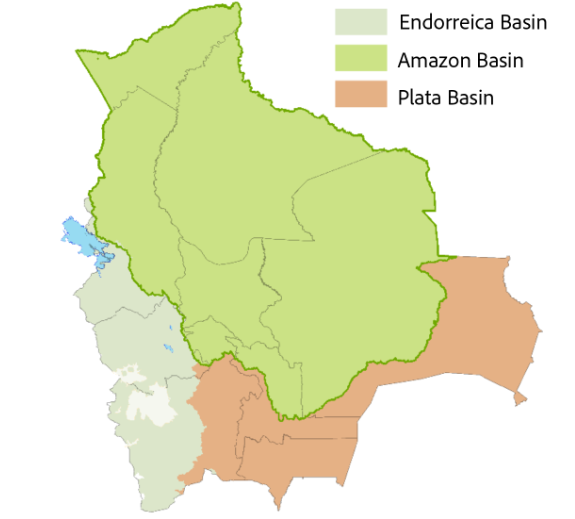
Source: authors’ calculation based on data from the GeoBolivia portal
The Amazon basin covers a large part of national territory. Housing approximately 50 million hectares of tropical forest, this basin in its entirety accounts for around 75 million hectares.
The ground coverage of the Bolivian Amazon basin is around 60% forest, followed by other natural non-forest formations (wetlands, prairies, and others) at around 25% (Amazon MapBiomes Project, 2022). Figure 2 shows the ground coverage of the Amazon in 1985, 2016, and 2021.
Figure 2: Land composition of the Bolivian Amazon basin, in 1985, 2016 and 2021


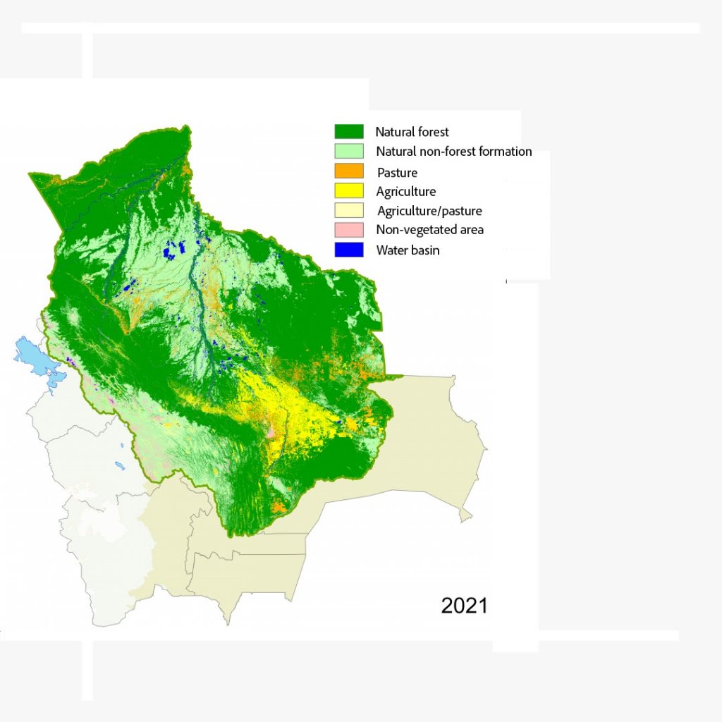
Source: authors’ calculation based on data from Amazon MapBiomes.
Figure 2 shows the growth of the share of land used for farming and ranching between 1985 and 2021. During this period, the amount of land used for agriculture increased by approximately 6.3 million hectares. We can appreciate that these changes respond to a transition of forest to agriculture use, primarily in the Santa Cruz region. The share of land taken over by non-vegetated areas increased significantly in the metropolitan areas of Santa Cruz, Cochabamba and La Paz between 1985 and 2021. During this period, total non-vegetated areas increased by approximately 0.2 million hectares.
On the other hand, the amount of forest land was reduced by 5.62 percentage points between 1985 and 2021. This reduction coincides with the increase of agricultural land, which together with land used for cattle ranching (agriculture, pasture, and pasture/agriculture mosaic) increased by 6.18 percentage points between 1985 and 2021, and by 2.65 percentage points between 2015 and 2021, doubling the annual average increase between those periods. The share of agricultural land increased from 2.53% of the basin in 1985 and 11.36% of the basin in 2021.
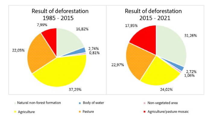
Figure 3: Land composition of the Bolivian Amazon basin
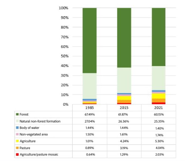
Source: authors’ calculation based on data from MapBiomes
The data shows a direct relationship between the loss of forest and in the increase in agricultural land. Of the approximately 48 million hectares forest land in 1985, 86.64% (42 million hectares) remained forest and the remaining 13.36% (6.4 million hectares) has been converted to other uses. As we can see in Figure 4, the forest areas that converted to other uses mostly became agricultural land, and the remaining land became other types of natural areas, such as grasslands, and wetlands, representing an area deforested without apparent human cause.
Figure 4: Change from forest to other type of area, 1985-2016 and 2016-2021
Source: authors’ calculation based on data from MapBiome
The area that changed from forests to other uses was 5.1 million hectares in total between 1985 and 2015, which makes an annual average of 0.17 million hectares. On the other hand, between 2015 and 2021, 2 million hectares of forest were lost, for an annual average of 0.33 million hectares.
In all of these areas, the change was mostly agricultural; however, in the 2015-2021 period we noted an increase in the percentage of deforested area that was converted into a natural, non-forest formation, meaning deforested land without apparent agricultural uses. This mainly means grasslands and scrublands. This could be due to the COVID-19 pandemic, but other causes should be investigated. Likewise, we note an increase in deforested area whose intended purpose is called pasture/agricultural mosaic, this type of cover refers primarily to areas in which it is not possible to distinguish between pasture and agriculture, due to their small size or mixed usage (Moreno and Camargo, 2022).
The deforested areas for agricultural use in the Bolivian Amazon can be identified in Figure 5. We can see that there are deforested areas in the north of Pando, the east of La Paz, diverse zones of the Beni, northeast of Cochabamba, and in the central and east zone of Santa Cruz, between 1985 and 2015, expanding north and east between 2015 to 2021.
Figure 5: Deforested areas for agricultural use in the Bolivian Amazon
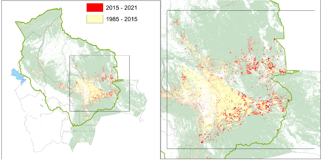
Source: authors’ calculations based on data from MapBiomes.
According to the World Wildlife Fund, the deforestation of the Amazon rainforest can bring the region’s ecosystem to the point of no return, which would cease to behave as a tropical rainforest, and this could occur within the next 20 years (World Wildlife Fund, s/f). The countries that make up part of the Amazon should consider their part in its development, and the sustainable use of the forest, in order to slow down the rate of deforestation in this valuable region.
Bibliography
Fundación Aquae. (2021, septiembre 22). Amazonia, descubre sus secretos. https://www.fundacionaquae.org/wiki/amazonia/
Moreno, N., & Camargo, R. (2022). Apéndice Agricultura Tema transversal en Colección 4.0. https://s3.amazonaws.com/amazonia.mapbiomas.org/atbd/atbd transversales/Apéndice_12_Agricultura_Colección_4.0.pdf
Proyecto MapBiomas Amazonía. (2022). Colección 4 de los Mapas Anuales de Cobertura y Uso del Suelo. https://code.earthengine.google.com/?scriptPath=users%2Fmapbiomas%2Fuser-toolkit%3Amapbiomas-user-toolkit-lulc.js
World Wildlife Fund. (s/f). Amazonia | WWF. Recuperado el 15 de febrero de 2023, de https://www.wwf.org.bo/paisajes/amazonia/