
 Español

The Qhapaq Ñan, also known as the Andean Main Road, is a communication route that has facilitated the development of cultures with a harmonious relationship with the natural environment (IDB, 2006). This road has been in use since the time of the Aymara Lordships in the 13th-14th centuries, but it wasn’t until the 15th century, during the Inca culture’s dominion under the Tawantinsuyu, that it began to evolve as a road system connecting major population centers with the coast, the Yungas, the highlands, and the Amazon (Lumbreras, 2006). In recognition of its cultural richness, the Qhapaq Ñan was designated a UNESCO World Heritage site in 2014. The Qhapaq Ñan embodies the cultural, economic, technological, ecological value of the road, along with the knowledge, beliefs, and practices of the communities settled along it (IDB, 2006).
In Bolivia, the Takesi road stands out as one of the best-preserved paths, located in the municipalities of Yanacachi and Palca in the La Paz department (Figure 1). It traverses various ecological zones and harbors a significant diversity of flora and fauna. The communities settled along the Takesi route include Takesi, Kacapi, and Chojlla. However, despite its well-preserved state, it faces various threats, such as mining, which is responsible for water pollution, riverbed destruction, and the construction of access roads for mineral transportation or machinery that damages the roads and associated archaeological sites (SALP 2014; Bar Esquivel et al. 2016).
Figure 1: Pre-Hispanic Takesi Route
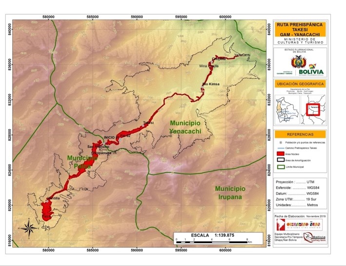
Source: Qhapac Ñan Bolivia Project (2019)
The way of life in the study area is characterized by peasant communities engaged in small-scale livestock and agriculture. Land ownership is primarily communal, with some individual-family ownership. Governance interactions define patterns of natural resource use, organization, and land management. Decision-making occurs through federations, central organizations, sub-centrals, and agricultural unions. However, tensions and disagreements within communities and among communities along the route hinder the implementation of management proposals related to tourism and conservation. For example, the project “Development of local capacities for the promotion of community cultural tourism integrated into the Qhapac Ñan in Bolivia, Peru, and Ecuador” could not be executed in the Takesi and Kacapi communities due to their concerns and distrust regarding property rights and buffer zones, which emerged during land tenure regularization by the National Institute of Agrarian Reform (INRA). This misinformation led the communities to reject the project.
Given the cultural and natural significance of the pre-Hispanic Takesi road and the threats to its heritage, it is crucial to develop territorial management proposals for its protection and conservation. Protected areas are a tool that can facilitate this, but they are not fully embraced by local communities, as they often entail the protection and conservation of certain resources or elements that conflict with local economic development interests[1]. An alternative approach is to include Takesi, along with its associated landscape, as a System of Life within the Comprehensive Territorial Development Plan (PTDI) of the Yanacachi and Palca municipalities. The PTDI aims to consolidate territories free from poverty with sustainable productive systems while preserving environmental functions (Ministry of Planning and Development, 2016).
To implement a territorial management tool within a protected area, it is essential to conduct a comprehensive diagnosis to understand the condition of the area concerning its natural and cultural heritage. This diagnosis should also provide insights into the socio-cultural context in which work should be conducted, offering a clear picture of elements that require greater intervention in terms of protection and conservation, and identify information gaps that need prioritizing.
Various methodologies were employed to conduct the study area diagnosis, including a literature review, satellite image analysis, and the application of tools such as Google Earth Engine, LandTrendr, and Snazzy EE-TS-GIF. Additionally, surveys were conducted with tourists totaling 115 surveys between March and May 2023.
The literature review confirmed the existence of various regulations, official and private documents, and research on archaeological, tourist, biodiversity, and heritage aspects of the Takesi road. Notably, Supreme Decree No. 12717 of 1975 declared Takesi road a National Archaeological Monument.
While satellite imagery revealed minimal significant changes in the study area, in-situ analysis, including direct observation and photographic documentation along the route, indicate deterioration in several sections of the road. This was particularly evident between Laguna Loro Qheri and the Takesi community, with issues such as neglected channels, disrupted paving that is no longer functional, and collapsed roadways and paths due to spring and rainwater. One significant change occurred in February 2018, when torrential rains and flash floods destroyed the pedestrian bridge over the Takesi River, and as of August 2023, it has not been rebuilt.
Figure 2: Collapsed pedestrian bridge due to Takesi River overflow
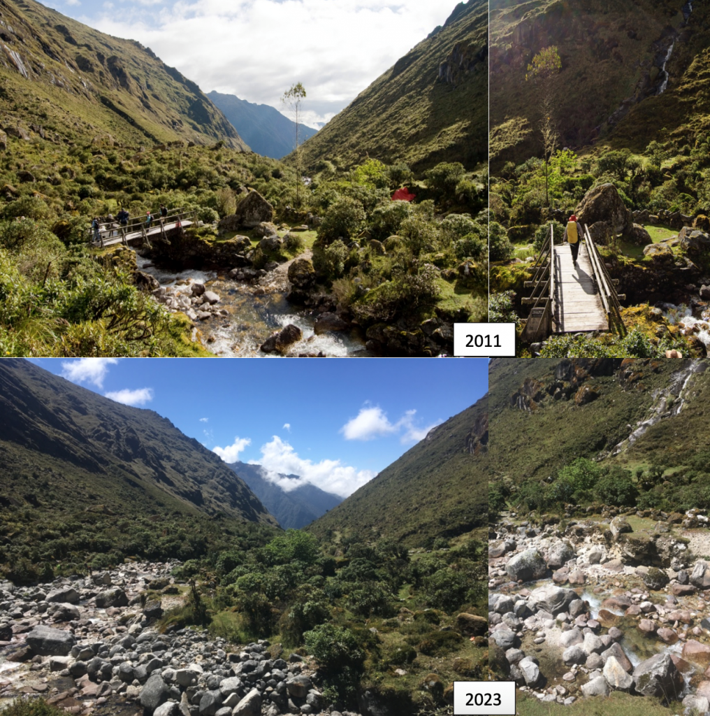
Source: Own photographs
Among the most critical findings from the tourist surveys were the visitors’ perceptions of landscape changes, the most important findings are the next:
Figure 3: Main changes identified by tourists on the route
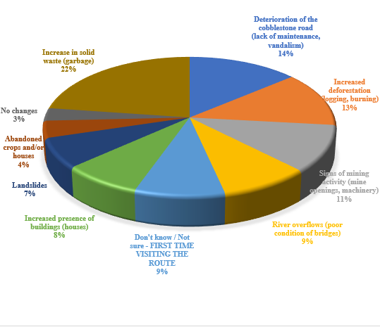
Source: Author’s elaboration based on tourist surveys
The primary changes on the Takesi route are related to increased litter and the deterioration of the paved road (Figure 3).
Figure 4: Perceived threats to landscape conservation
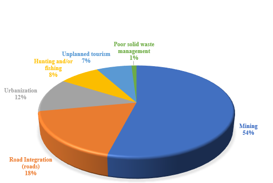
Source: self-prepared based on tourists surveys
The most significant threats and negative impacts identified, in a higher percentage, included mining as the activity with the most negative impact, followed by road construction and urbanization (Figure 4). Currently, mining activity in the upper part of the basin is not of significant magnitude; however, several locals are involved in gold mining in other regions. While mining presents a potential negative impact, according to Bar Esquivel (2023), road integration and urbanization are the main threats and causes of harm to pre-Hispanic roads.
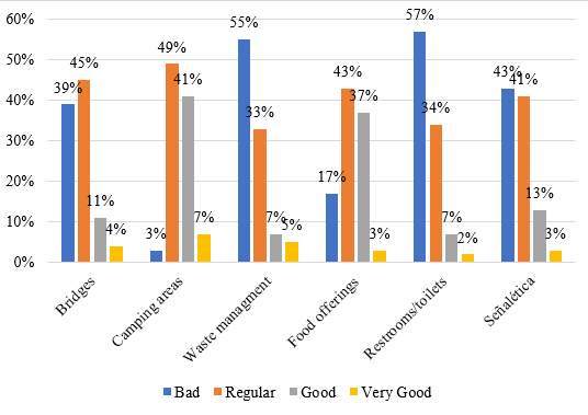
It’s essential to mention that unplanned tourism activity can also represent a potential negative impact on the landscape and the Takesi route. This activity currently serves as an income source for communities that offer various tourist services.
Figure 5: Evaluation of tourist services on the route
Source: self-prepared based on tourists surveys
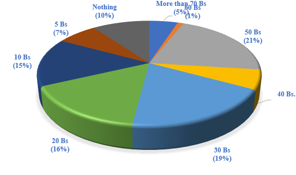
However, there is dissatisfaction among tourists regarding the quality of some of these services (Figure 5). Importantly, there is currently no formal fee collection system for access to the Takesi road. In this regard, survey respondents were asked about their willingness to pay for entry to the route, and the responses are as follows:
Figure 6: Willingness to pay for access to the Takesi road
Source: Author’s elaboration based on tourist surveys
In addition to the mentioned amounts, even though a formal method for economic valuation to establish a possible entry fee has not been applied, the results indicate a positive willingness to make a financial contribution (Figure 6). This is provided that the funds are used to improve and conserve the Takesi landscape and route, as well as the quality of tourist services.
To preserve the valuable natural and cultural heritage of Takesi, it is essencial to identify conservation objects that comprehensively represent the biodiversity of the study area and reflect its threats. Using the Manual for the Conservation of Areas (Granizo et al., 2006), the following conservation objects were identified:
– Pre-Hispanic road: Paved roadway, footpaths, water canals, walls, terraces, tambos.
– Local communities: Takesi, Kacapi, Chojlla.
– History and oral tradition of the route.
– Sustainable agricultural systems.
– Water system: Loro Queri, Wara Warani lagoons, Queriosible wetland, Takesi River and its tributaries, springs, and water sources.
– Forests: a) montane forest (3,500 – 2,500 meters above sea level) and b) montane or Yungas Forest (2,500 – 1,000 meters above sea level).
– Large mammals: Andean Bear (Tremarctos ornatus), Puma (Puma concolor), and Taruka (Hippocamelus antisensis).
– Queñua (Polylepis) forests and associated fauna.
These natural and cultural conservation objects comprehensively represent the Takesi cultural landscape and should be considered in management projects, whether through a municipal protected area, a communal conservation area, or a System of Life, within the Comprehensive Territorial Development Plan (PTDI) municipal framework. This should encompass the three fundamental pillars: environmental functions, sustainable productive systems, and the eradication of extreme poverty.
Final Remarks
It was observed that the cultural landscape of Takesi has undergone minimal changes over the past 30 years. The passage of time and lack of maintenance have been the primary causes of deterioration. However, there are threats such as mining, road integration, urbanization, and unregulated mass tourism that can irreversibly affect this natural and cultural heritage.
Local sociocultural units or communities have maintained a sustainable relationship with life zones and ecological zones over several generations through diversified activities for their livelihoods. Exchange relationships between communities settled along the Takesi route have diminished due to increasing migration, hindering effective and participatory land management.
The communities along the route engage in various livelihood activities, including agriculture, livestock, mining, and tourism. Although tourism currently provides income to the communities, it is most significant during national and departmental holidays. While there is a willingness and interest in developing tourism in the area, many individuals cannot dedicate themselves to this activity because their primary sources of income are located outside the community.
Despite the identified issues, the pre-Hispanic Takesi road is supported by a substantial normative and academic framework that serves as a solid foundation for its conservation through comprehensive management that considers all elements related to this heritage. However, it is crucial to recognize that this heritage is dynamic, and the regulations and projects for its management must adapt to this ever-changing context of the Takesi landscape and route. They should consider a long-term projection to maintain its intrinsic values.
Achieving comprehensive management of the pre-Hispanic Takesi road and its associated elements is essential for local development due to the cultural, ecological, and economic potential it represents. To reach this goal, the participation of all involved stakeholders, especially local populations, is necessary. It is vital to work from the concept of common goods, which has facilitated the conservation of the Takesi road. Moreover, it’s essential to consider this cultural landscape as a constantly changing asset that requires management and valuation tools that respond to its dynamic and complex reality.
Footnotes
[1] According to key informants along the Takesi route, Aps (Protected Areas) involve external management and the imposition of regulations and restrictions on their communities. As a result, most of them reject this territorial management instrument. This percepction regarding Aps is also present in other contexts, as analyzed in the study: “Analysis of Conflicts between Local Communities and Conservation Authorities in Colombia. Causes and Recommendatios” (De Pourcq, K. et al. 2017)
Bibliography
Inter-American Development Bank (IDB). (2006). The Qhapaq Ñan Andean Main Road. Regional Action Plan for an Integration and Cooperation Process. UNESCO. Peru.
Bar Esquivel, Alfredo et al. (2016). Guide for the Identification and Registration of Qhapac Ñan. Ministry of Culture of Peru. Lima.
De Pourcq, K., Thomas, E., Van Damme, P., & León-Sicard, T. (2017). Analysis of Conflicts between Local Communities and Conservation Authorities in Colombia. Causes and Recommendations.
Granizo, T., & et.al. (2006). Planning Manual for Area Conservation, PCA. TNC and USAID, Quito.
Lumbreras, Luis. 2006. Presentation. In: IDB 2006. The Qhapaq Ñan Andean Main Road. Regional Action Plan for an Integration and Cooperation Process. UNESCO. Lima, Peru.
Ministry of Planning and Development. 2016. Methodological Guidelines for the Formulation of Comprehensive Territorial Development Plans. La Paz, Bolivia.
La Paz Archaeological Society (SALP). 2014. Takesi Road: conclusions of the evaluation on damage and destruction. Available online at http://www.arqueologialapaz.org